|
 This website documents our (Denise and Mark) bicycle ride around Australia between March 29, 2009 and March 28, 2010. This website documents our (Denise and Mark) bicycle ride around Australia between March 29, 2009 and March 28, 2010.
Traveling in an anticlockwise direction around Australia, we visited each of the state and territory capital cities of Brisbane, Darwin, Perth, Adelaide, Melbourne, Hobart, Sydney and Canberra.
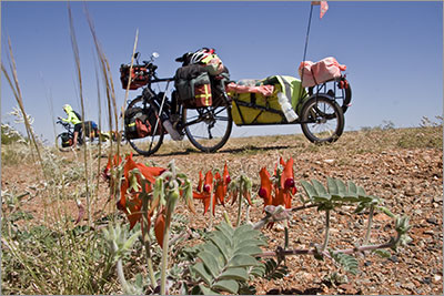
Originally we planned to take 10 months to complete the journey but along the way we decided to stretch it out to 12 months so that we could see and experience as much as possible. The ride was unsupported with us carrying everything we needed on our bikes and BOB trailers.
During the journey we kept a hand written diary and uploaded a summary of each day’s activities to this website. Each daily report includes a zoomable and scrollable Google map showing our new location as well as some photographs for that day. Our archived reports can be retrieved from the Daily Reports page.
(Update February, 2024. Due to the ongoing time commitment required to keep the Google Map feature working with current browsers we have reluctantly decided to remove the Google Map feature from our Daily Reports.)
Our About page includes the background information about why we chose to undertake the journey and all the answers you may be looking for about "Sprung Chickens".
For both Denise and I the past 12 months have been extremely enjoyable. There were some hard days and a few low points along the way. Sometimes we found the combination of distances and head winds overwhelming and rather than being a physical challenge the journey became one requiring a strong mental will. We only found one hill we could not ride up. For the most part our time away was one big high.
Moving so slowly through the Australian landscape we saw and experienced a very different country to what we would have from our car. One of the standout memories will always be the people we met and befriended along the way, as well as the times we reconnected with friends from home as they undertook shorter journeys through different parts of Australia. This was a journey that we will never forget.
Each day we would meet someone different and invariably we would be asked questions about our journey. In no particular order here are some of the common questions we have been asked.
- Where are you from? We live in Canberra, the nation’s capital. Yes we are Australian (oddly not a common nationality for cyclists travelling around Australia).
- Where are you going? We are cycling around Australia. Sticking to the coast as much as possible we are planning to visit every state, territory and capital city along the way.
- How long have you been riding? We seemed to be asked this question every day. Some days, particularly after updating our diary, we knew exactly what day number it was so we could for example reply, “This is day 186”, which always seemed to impress. In all we were away 364 days.
- What do you eat? This was one of the most commonly asked questions and to start with it rather amused us as we thought it a rather odd question to be asked. Mostly we ate what we did at home. But we began to realise that people travelling in cars and caravans with their fridges and freezers had no idea on how to manage without such appliances. On the east coast when we were travelling between towns every day we would shop each night for fresh meat, vegetables and fruit. Across the interior and along the west coast we used tinned goods as dried food required water that also needed to be carried. We could carry food for 8 days and this included fresh fruit. We had a water carrying capacity of 65 litres that with temperatures in the high 30’s and low 40’s lasted three days. Sometimes we told people we ate ‘road kill’ until we realised that some thought we were serious. For an example of a main course see Day 109 and for an example of dessert see Day 271.
- What has been the highlight? This has always been a hard question to answer, as the journey was a combination of highlights, which now we are home, we are continually recalling. We very much enjoyed the isolation and our time in the outback.
- Have you had any bad experiences? We both fell ill for different periods in Western Australia but other than this we only had one bad experience, see Day 167.
- How many kilometres do you do each day? This has varied between 16.7km and 195km and depended on the weather and terrain. The 16.7km was on Day 296 and into a strong westerly wind along the north west coast of Tasmania. Our ‘record’ of 195km was on Day 243 and also involved a strong westerly wind. We have never crunched the statistics but suspect on the “Big Island” we averaged 100km a day whilst on the “Small Island” it was probably closer to 70km a day.
- Where do you sleep? We carried a tent but also used hotels, motels, B&B’s and cabins.
- How do you manage with the trucks and road trains? When we left on our journey we were told to watch out for crocodiles and road trains. It was only after we reached Perth that we realised we had not found any reason to worry about crocodiles. Road trains and trucks were the same. Except for one instance of a road train coming extremely close north of Broome (we coincidentally recorded this on video), the trucks and road trains always gave us a wide berth. Mostly the truck drivers were very friendly always offering a wave or a toot of encouragement. We always wondered how many times they would pass us as they drove their regular routes. Across the Nullarbor we suspect the truckies undertaking the drive ‘across the paddock’ may have passed us four times in the time that it took us to do the same crossing.
Update December 2010. In April 2010 we submitted an article reflecting on the safety aspects of our trip to the Canberra Cyclist a magazine published by Pedal Power. We asked and answered the question "How safe is it on Australian roads for bicycles?" For unknown reasons Pedal Power failed to publish this article. However, because it deals with the issues of safety and the visibility of cyclists on Australian roads we have decided to add a link to the article here. Read “Take Control and Minimise the Risk.”
- How many punctures have you had? We very proudly announce we had no punctures on either of our bikes and only two punctures on each of our trailers. Early on we did change a few tubes with suspected punctures until we realised we had loose presta valves. So absolutely no punctures on our bikes. We suspect this is a record as we have not heard of any other cyclists being so lucky.
- How many tyres have you gone through? We started with new tyres and carried one spare for the bikes and one for the trailers. On the bikes we changed both rear tyres in Darwin and then both front and back tyres in Adelaide. Due to damage we changed the tyres on each trailer once. One of the trailer tyres turned out to be faulty and was swapped by our supplier under warranty.
- Have you had any problems with the bikes? Other than general wear and tear we had no significant problems with our bikes. Being an unsupported ride across a lot of remote country we did carry 7kg of spares and tools with us. This allowed us to change one front and rear derailleur and service the bikes at regular intervals. In Perth we changed all the chain rings and rear sprockets which we purchased before leaving Canberra and then had posted to us once we knew where we were staying. We replaced two back rims and one front rim after discovering cracks around the spoke nipples, in this regard we are trying to take this matter up with the rim manufacturer.
- Do you get sore bums? Other than on really really long days we found our saddles to be very comfortable. See Day 82.
- Who is looking after the children? Another surprisingly often asked question. Our children are 21 and 27 so are able to fend for themselves.
- Are you still talking to each other? Another surprisingly often asked question. We have been married 28 years and for the last 14 years have run a business together, so we are very comfortable in each other’s company. So yes we are still talking to each other. See Day 206 – 215.
- How many photographs have you taken? Both of us had cameras. Whilst we were travelling we had no idea how many shots we had taken. However, after we returned home we converted all the camera raw images to digital negatives and the software reported converting 14014 files – roughly 38 shots a day. On top of this we have all the jpeg files from the other camera. Before we converted the camera raw files we transferred all the backup DVD’s to a hard disk and discovered we had accumulated nearly 700GB of video, photos and audio recordings. Most of the video and photographs can be geo tagged.
- Do you keep a diary? Between the two of us we kept a hand written diary.
- Do you have a website? Yes (you are reading it). As much as possible we updated the site every couple of days although on occasions this did stretch out to 10 days. In the end we are glad we created and maintained the web site but it was very demanding of our time.
- Are you going to write a book? After being asked this question a lot we have decided to set aside some time and attempt to write a book about our journey.
And now to dream about our next journey!
Top |