


| Home | Daily Reports | April | Day 25 |
| Day 025, Wednesday, 22 April, 2009 Distance travelled – 53.27 km Chinderah, Pacific Highway, Tweed Heads, Coolangatta, Esplanade, Currumbin, Pacific Highway, Broadbeach, Esplanade, Surfers Paradise, Southport It rained early this morning and it took a little while for us to get going. Mark got distracted talking to one of the residents who had a very interesting shed across the road from our cabin. It was full of model aeroplanes, the owner being a keen designer, builder and flyer. By the time we departed for the Gold Coast the skies had cleared and it was starting to warm up. Surprisingly there was no obvious sign indicating we had crossed the NSW / Queensland border, or if there was we didn’t see it. (Our video replay shows no sign either). Anyway, we suddenly realised we were in Coolangatta and Queensland. We wound our way along the coastline on a mixture of paths and roads and stopped at Broadbeach for lunch. In the marketing hype we read about the Gold Coast we were told the gold in the name Gold Coast comes from the “golden unpolluted beaches” and the hills behind the Gold Coast are referred to as the “green behind the gold”.
As you can see from the photo at left this is a very striking sculpture but how the above description can be used to describe it we do not know. Has it faded or are we missing something? We then headed for Surfers Paradise with the aim at stopping at the information centre to enquire on the best way to get to Brisbane. As we were following our nose into Surfers using a mix of bike trails and roads we turned the GPS off as it kept complaining we were going the wrong way. As we neared Surfers a tail wind started to push us along at a steady rate and we were ‘enjoying’ ourselves so much that we suddenly discovered that we had overshot our destination the, Cavill Avenue Mall, by 3km ;-(. We ended up covering the same bit of road three times, part of which was along the course used by the Indy and V8 Supercars. I do not know how they drive these cars so fast on such an uneven surface.
Zoom into the map and use the 'Satellite' layer to see our new location.
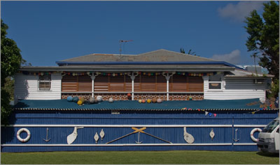
Building decorations near Tweed River Seafood
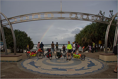
Denise and bikes below Surfers Paradise arch, rainbow in background. |
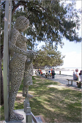 When we pulled up for lunch at the beach at Broadbeach we discovered a sculpture called ‘The green the gold and the blue’. It has three components, a surfboard with the Rotary International logo, a girl in a bikini and a young child. The plaque beneath reads – “The green is for the rain forests of the hinterland and the green of the parklands. The gold is for the colour of the sand on our beaches and the golden sun for which the Gold Coast is renowned. The blue is for the unique colour of the ocean and our skies. Green and gold are the national colours of Australia. Blue and gold are the corporate colours used by both the Gold Coast City Council and by Rotary International. The sculpture portrays an overview of the community of the Gold Coast its families and its environs.”
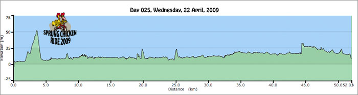
Home | Daily Reports | About | Contact Us | Merchandise | Site Map
© 2008 Mark Arundel